The GTA Place - Grand Theft Auto news, forums, information, screenshots, guides, cheats...
GTA IV Map Partially Revealed?
GTAForums member BlueSpot has spotted what could well be the map of Liberty City in a scene in the third trailer. The screenshot (below) shows what we believe to be the map. From the left we can assume this would be Alderney (cut off), Algonquin in the middle, Broker on the right, and Bohan at the top.
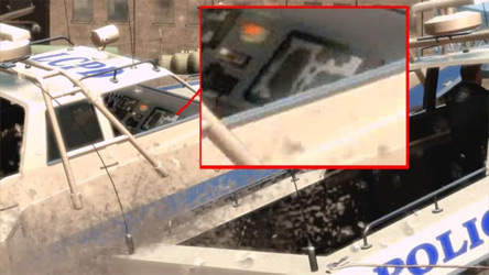
Obviously we can't tell for sure due to the lack of detail, but it's an interesting find nonetheless.

that IS a good find. you see, its stuff like that i cant catch when i look at the trailers. if it is the map though, it doesnt show too much.

Good find if it is the map, but if it is, it's going to be interesting to see what happens at the points where the landmass reaches the edge of the map, as all the other 3D maps have been surrounded by water.
yea. you just brought that to my attention now. since its supposed to be a remake of NYC, i wonder what R* will do with that...


I highly doubt it but, sharp eyes.


This is a good find IF it is the real map ... I can't find another game except GTA where the gamers put the screenshots and the trailers at microscope  Also, noticed there is the same "map" on the other side of the red button too, it's a bit smaller but the same ...
That's cuz these guys are GTA4 info/map junkies... ![]()


Probably just a detail (for cop car), like the VC maps in SA trashcans.

To be honest, this might not even be a real map. They're not accurately building New York, and if they were to, we'd realize that it's actually a full map of New York. This could possibly be a part of the map, or it could be completely fake. I'm not so sure whether to believe it's a full front end map which is actually what most people think, but it could be part of the inside, or as most of us would call it, the texture's of the interior.
For one, that could be possibly true that it could be fake, especially with it having a texture of the map, but they could just be making this map up just for show. But seeing that it looks partly different to a real map, I'd say it's fake. Also K9, that long black thin part of the land looks like a really thin, but long penis.


Good find if it is the map, but if it is, it's going to be interesting to see what happens at the points where the landmass reaches the edge of the map, as all the other 3D maps have been surrounded by water.yea. you just brought that to my attention now. since its supposed to be a remake of NYC, i wonder what R* will do with that...
Um, Liberty City has always been "New York".... They could still do the same thing they did last time....

It could be a GPS tracking system and it`s showing all the places like Algonquin and the others,so I guess it could be part of the map,or it could be
It probally is. I looked closely and some of the black kinda looks like a dot like on all the mini-maps in the past GTA games.
I do think this is (part of) the map in IV.
If u guys still think its not libery City.... then y does the cop boat have the letters LCPD (Liberty City Police Department)..
they prob redid the map... to make it bigger or better, cuz in GTA 3 it wasn't hard tofind your way around the city since there were only like 3 real roads in the game.

If u guys still think its not libery City.... then y does the cop boat have the letters LCPD (Liberty City Police Department)..they prob redid the map... to make it bigger or better, cuz in GTA 3 it wasn't hard tofind your way around the city since there were only like 3 real roads in the game.
We all know it's Liberty City.
I don't think it is a map unless it's part of a map. It could a map of one of the districts in Liberty City or a GPS system but I'm not too sure that it is the "real" mp if you know what I mean.

I really like this post. very good eye to whoever caught it. I like watching the trailers frame by frame too lol.
Website
Spotlight
Latest Forum Topics
News Headlines
- GTA VI Trailer 2 Released, Officia...
- GTA VI Delayed Until 26 May, 2026
- Grand Theft Auto VI Trailer 1 Rele...
- Next Grand Theft Auto Trailer Comi...
- Finally: Rockstar Officially Confi...
- GTA Online: Bikers DLC Out Now
- GTA Online: Bikers - Coming Soon
- GTA Online: Cunning Stunts Now Ava...
- GTA Online: Further Adventures in ...
- Liberty City Stories Released on i...
Featured Content
Users Online
Website: 140
Forums: 771
Total: 911
Special Features
Poll
Social
Network
This fansite is officially recognised by Rockstar Games, but is owned and run independently.
About | Advertising | Privacy Policy & Cookies | Manage Cookie Settings
Comments